Dear WeatherCat West coast
drought (?

?) watchers, . . . .
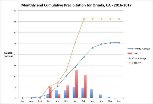
February continued the trend well above normal rainfall bringing in 10.66" - 224% of normal. As a result, the region has already received 142% of the rainfall than would be expected in an entire normal rainy season as can be seen in the current graph:
As noted earlier, the National Weather Service Climate Prediction Center had a
very dry outlook for March. However, this expression of gloom and doom may have been premature. The current 6-10 day, and 8-14 day outlooks have shifted from below normal precipitation to neutral. In addition, this morning's forecast discussion ended with this rather cryptic paragraph:
Beyond Sunday models are having difficulty with the pattern and potential for rainfall. General trend over the past few runs has been wetter with the ridge struggling to rebound. This could lead to one or two additional chances of moisture. Needless to say, anyone with outdoor plans from Sunday into the middle of next week should stay tuned.
So as
da' man sez . . . .
stay tuned!! 
Cheers, Edouard
![[cheers1]](https://athena.trixology.com/Smileys/default/food-smiley-004.gif "Cheers")


