Dear WeatherCat drought watchers,
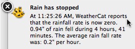
So far it has been a dry to normal rainy season for California. However, December and January has finally started bring us substantially above normal rainfall. My Vantage Pro-2 console tells the tale on the latest storm:

Since I took that photo we have picked up some additional rain and find ourselves at 3.81" (96.8mm) for the storm. There might be another bucket tip or two before it is completely over. Today brought us a sustained period of heavy rain:
At least in California, picking up almost an inch of rain in 5 hours is enough to bring about a risk of flooding especially when the ground is already saturated.
I went around the area this afternoon to take a look at the effect. I didn't find any damage but some areas clearly were flooded during the peak rains. The effect of the running water was interesting. I took this photo of water jumping over a concrete obstruction in the street gutter:

Here is a small creek that was rushing into the storm drain system:

I didn't see any signs of landslides but the ground is plenty saturated. I saw this "natural drain:"

I"m guessing a gopher or other natural hole became a impromptu drain for that hill.
Here is one last photo of that fallen tree that I posted earlier. It has finally gotten cut into pieces:

That gives you a good idea of the size of that tree! No other trees have fallen but the same property had another tree in the process of being taken down. They weren't taking any more chances!
We are already 20% over the rainfall for January with more rain expected at the end of this week and probably more rain before the end of the month. We are also at 98% of normal rainfall for the year (July-January.) So we are guaranteed to finally pull ahead of normal rainfall for period for the first time this rainy season.
The drought is a long way from over, but December and January have both been wet. If February and March follow suit, it might be enough to end water restriction. Here's to hoping!

Cheers, Edouard
![[cheers1]](https://athena.trixology.com/Smileys/default/food-smiley-004.gif "Cheers")


