Dear WeatherCat West Coast drought watchers,
No rain is expected through the end of January so I decided to write up this month a bit early. As reported during the month, Northern California ended up with epic rainfall for January:
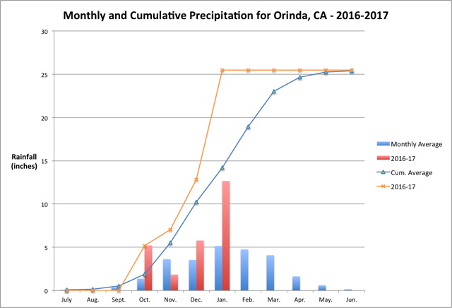
As you can see from the graph we have already received more rainfall than we normally expect for the entire rainy season!
January brought 246% of what normally falls this month. As a result, we have 180% of the rainfall we would expect to have through the end of January for the season.
We are expecting another reasonably potent storm at the end of this week. However, at the moment the weather is unusually warm and pleasant because of a very strong ridge of high pressure. While we do need to dry out, we definitely do not need a 180 degree turnaround with an extended period of dry and warm weather. The National Weather Service, Monterey office had some ominous words at the end of this afternoon's discussion:
Fairly strong indications that the next round of widespread rain will be it for awhile. The outlook for all of next week is for warmer than normal temperatures with drier than normal conditions as the ridge rebuilds back into the southwest Conus.
The Climate Prediction Center is less pessimistic with normal conditions expected for Northern California on the 6-10 day, 8-14 day, and experimental week 3-4 outlook.
Cheers, Edouard


