Author Topic: NWS - Climate Prediction Center forecasts - Autumn 2020  (Read 1180 times)

elagache

  • Global Moderator
  • Storm
  • *****
  • Posts: 6494
    • DW3835
    • KCAORIND10
    • Canebas Weather
  • Station Details: Davis Vantage Pro-2, Mac mini (2018), macOS 10.14.3, WeatherCat 3
NWS - Climate Prediction Center forecasts - Autumn 2020
« on: October 02, 2020, 10:15:47 PM »
Dear WeatherCat climate watchers,

Autumn is upon us and here is the first 1 month and 3 month forecasts from the National Weather Service - Climate Predication Center for the start to the season.  Here is the one month forecasts of departures from normal temperatures for October:


I'm not sure how X-Air will take that cooler than normal region in the south.  For most of the rest of us it is expected to be above normal.

Here is the equivalent 3 months predictions of temperatures departures from normal for October through December:


This is back to the "hot everywhere" forecast that we periodically see.

Here are the precipitation predictions of departures from normal for October:


Curious that there is a near perfect "bull's eye" of below normal rainfall for most of the country.  Only the upper edge of the Pacific Northwest is expecting above normal rainfall.

Here is the equivalent graph for October to December:


There is less certainty in this forecast with the "bulls eye" now centered on Texas.

On to drought forecasts.  Here is the drought outlook for October:


Drought starts to move east and north from the areas where drought is already present.  The 3 month outlook continues this trend:


Drought also extends southward as well although states in the northern 1/3 of the country are expected to get some relief.

Here are the Wildfire predictions.  These come from the NICC - National Interagency Coordination Center.  These come only monthly.  Here is the updated October:


This forecast is consistent with the risks to California and Oregon also areas around the 4-corners.    Here is the November outlook.


California ends up being the final higher than normal risk in the west.  Here is December:


Finally, the fire risks retreat only to Southern California, but Texas and nearby locations end up becoming a risk - presumably because of insufficient rainfall. 

As usual, Like it or not, such are the forecasts we are facing . . . . 

Edouard

elagache

  • Global Moderator
  • Storm
  • *****
  • Posts: 6494
    • DW3835
    • KCAORIND10
    • Canebas Weather
  • Station Details: Davis Vantage Pro-2, Mac mini (2018), macOS 10.14.3, WeatherCat 3
November (Re: NWS - CPC forecasts - Autumn 2020)
« Reply #1 on: November 02, 2020, 10:06:20 PM »
Dear WeatherCat climate watchers,

We have reached November and here is the first 1 month and 3 month forecasts from the National Weather Service - Climate Predication Center for the start to the season.  Here is the one month forecasts of departures from normal temperatures for November:


This is back to a "hot everywhere" sort of forecast.

Here is the equivalent 3 months predictions of temperatures departures from normal for November through January:


This is more of the same with the curious strand of cooler than normal from the top of Washington state to Alaska.

Here are the precipitation predictions of departures from normal for November:


The "bull's eye" from last month has been spread out but below normal rainfall is expected for a large part of the country

Here is the equivalent graph for November to January:


It is similar but with a clearer band of positive rainfall for the states in the northwestern part of the country.  This could be due to La Niña. 

On to drought forecasts.  Here is the drought outlook for November:


In the west, drought is expected to persist or get worse in many areas.  This appears to be also due to La Niña.  The 3 month outlook continues this trend:


Definitely looking like difficult times in the west.

Here are the Wildfire predictions.  These come from the NICC - National Interagency Coordination Center.  These come only monthly.  Here is the updated November:


Only California is expected to have increased fire risks.    Here is the December outlook.


Only southern California is left with a higher risk.  However there is a curious band starting in Texas.  Here is January:


Like last month, regions around Texas are facing a higher wild fire risk. 

As usual, Like it or not, such are the forecasts we are facing . . . . 

Edouard

elagache

  • Global Moderator
  • Storm
  • *****
  • Posts: 6494
    • DW3835
    • KCAORIND10
    • Canebas Weather
  • Station Details: Davis Vantage Pro-2, Mac mini (2018), macOS 10.14.3, WeatherCat 3
December (Re: NWS - CPC forecasts - Autumn 2020)
« Reply #2 on: December 02, 2020, 10:52:19 PM »
Dear WeatherCat climate watchers,

We have reached December and here is the first 1 month and 3 month forecasts from the National Weather Service - Climate Predication Center for transition from Autumn to Winter.  Here is the one month forecasts of departures from normal temperatures for December:


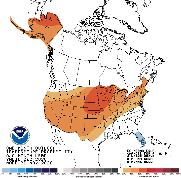
Like last month, this is back to a "hot everywhere" sort of forecast.

Here is the equivalent 3 months predictions of temperatures departures from normal for December through Feburary:


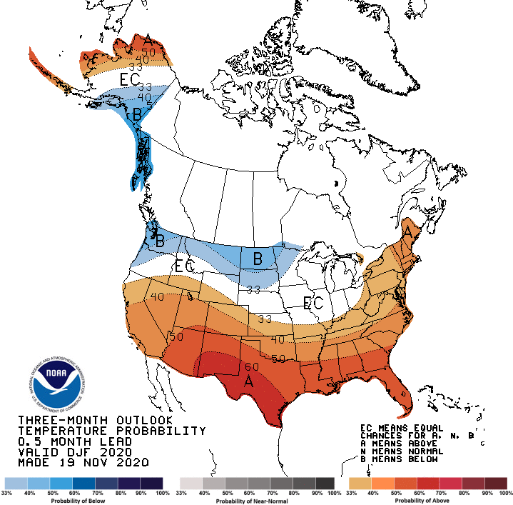
Once more repeating last month, this is more of the same with the curious strand of cooler than normal for the top western states all the way to the Great Lakes.

Here are the precipitation predictions of departures from normal for December:


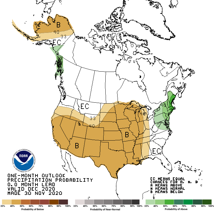
This forecast places almost all of the country at either below normal rainfall or equal chance.

Here is the equivalent graph for December to Feburary:


It is similar but with a clearer band of positive rainfall for the states in the northern part of the country.  This could be due to La Niña.  If so it would appear that the rain band has been shifted further north than in previous La Niña events.

On to drought forecasts.  Here is the drought outlook for December:


This is very similar to last month.  In the west, drought is expected to persist or get worse in many areas.  This appears to be also due to La Niña.  The 3 month outlook continues this trend:


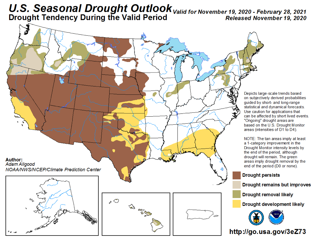
Definitely looking like difficult times in the west.  Only the Pacific Northwest and the most northern edges of the Atlantic seaboard are expecting some drought relief.

Since we are at the onset of Winter, I decided to skip the wildfire forecasts.  The are essentially identical to what was reported last month.  These come from the NICC - National Interagency Coordination Center, so you can look them up for yourself.

Unfortunately, these forecasts may be actually optimistic.  Parts of Central and Southern California are facing Public Safety Power Shutoffs because a strong Santa Ana wind event later this week.  Definitely looking like very difficult times in California and indeed all over the West.

As usual, Like it or not, such are the forecasts we are facing . . . . 

Edouard